I keep seeing that we shouldn't worry about the size of Night City because of the verticality of it...so does V know parkour? Because unless she's as skilled as the main characters in Dying Light or Mirror's Edge, or a majority of buildings can be entered (which I seriously doubt), other than looking up and going "ooohhh" and "ahhhh" at the sheer height at them until it's not that special anymore, what part does the verticality play in the game?
I keep seeing that we shouldn't worry about the size of Night City because of the verticality of it...so does V know parkour? Because unless she's as skilled as the main characters in Dying Light or Mirror's Edge, or a majority of buildings can be entered (which I seriously doubt), other than looking up and going "ooohhh" and "ahhhh" at the sheer height at them until it's not that special anymore, what part does the verticality play in the game?
We haven't seen AC levels of vertical climbing or the horizontal pole swinging, and recovery roll from DL but we have seen ledge climbing, wall running, double jumps(mentioned charged jump is also a skill), wall jumping from the hooked mantis blades, air dashes, slides, and vaults. Accompanied by running most of the time, I think that's pretty decent mechanics to able perform parkour in a game considering they allow the ninja playstyle. Just without the fancy Dying Light animations. They mentioned that they had to fix some level designs to make it possible but at the same time not game breaking to the point where you could "level skip" important story segments that wasn't meant to be skipped.
..now, if only we were able to carry stuff like tables or boxes.. that would've been very interesting..
Hello everyone. This will be big. And you will LOVE it.
I am new to this forum. I basically came here just to share my findings with you all.
So over the last couple of days, I've been working on something big. I've been working on making the most detailed map of Night City to date, based solely on screenshots, trailers and gameplay demos.
It proved to be a very difficult and time-consuming task.
Yesterday I noticed that there were at least two other people who attempted to do the same thing like a year ago, albeit in a more limited scope. They tried to locate Watson.
They failed. And I have proof. And (I think) I succeeded. And I have proof for that also.
Drawing the map turned out to be very difficult, but it's easier if you have such autism like I do, lol (no offense to people on the spectrum). Anyway, there was a lot of misinformation spread around the internet and around the promo-shoots themselves. I will address all of them later. Anyhow, what I did was basically analyzing trailers, screenshots and 15-50 minute gameplays shot by shot, looking at the distinctive buildings in the foreground and in the background, drawing connections, checking similarities, establishing perspectives and fitting it all in one place. It was tremendously exhausting and I must've spent a good 7-10 hours in total making this map and triangulating every location together.
But as you find that single sweet location, you find it very easy to go from there, it's just a matter of triangulating everything together, no longer having to worry about the geographic context of the map as a whole.
What I would say was very helpful was the metro map shown for a split second in the 2018 E3 trailer. It was a bit troublesome as well. I'll go into that later, in an other post. The second most helpful thing was the compass that was present in the UI in the 2018 48-minute gameplay demo. Together with the metro lines, it helped piece together the reality of Night City as it really is. And it did provide some very important evidence for why some things should be there and not anywhere else.
Anyway, what I also want to get across here is that you shouldn't 100% believe everything you find in the demos. The game is still in development, so there are lots of placeholders and other information that is already outdated.
Well, enough talking. Here is the map. It is as detailed as can be, I thought about mapping out various highways, but that would be impossible as there simply isn't enough material out yet.
This is what Night City will probably look like. Like 90%. Make sure to save this, share and spread this on the internet, inform your friends - whatever. It will sure satiate some hype, and when the game gets released, we'll be able to compare and see if I was off by any margin at all.
Enjoy! (post containing evidence and debunking earlier assumptions, also the ones in the thread "The sheer scale of Night City", will come after this one, I just need to drop this map off my chest)
So, as for evidence - I don't think I need to list all of it. What I'm gonna show you guys will be enough to prove that I am (most likely) right. Sorry that I sound so prideful but.. I really am pride of what I accomplished
So basically. The metro map, the compass, triangulation of the landmarks. That's how I'd say I got it.
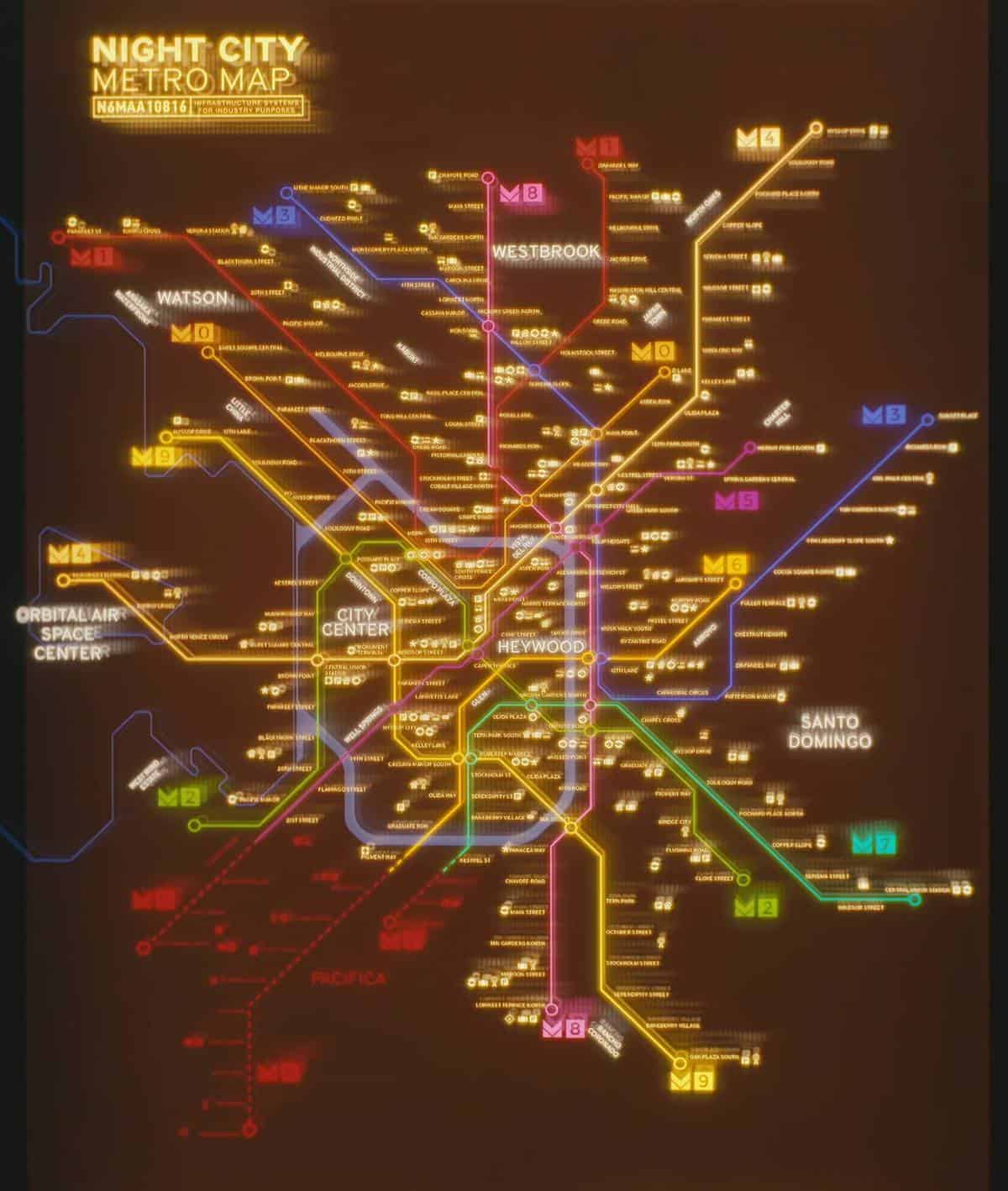
We'll start off with the metro map.
So as you can see, there's a bit to unpack here. First off - the names of the stations aren't exactly right. They seem to be simple placeholders, with many repeating and containing bland names, such as bird names, number names and so on. It was useful to determine the city limits and the possible boundaries of the districts though.
What intrigued me at first was the thin blue line dividing the Orbital Air Space Center, and the rest of the city. I thought it depicted a river at first. Then I noticed the OASC was surrounded by a thin blue line of its own. A circular river?? Surely it can't be.
So I discovered (and turns out those 2 folks earlier did so too) that it in fact depicts not a river, but a shoreline. The OASC resides on an island! And what we can clearly make out here is a bay. I tried to use a bit of imagination, skill, intuition and most of all - the materials given, to determine the most likely look of the whole area.
Then, I overlayed the metro map on my own map, and drew the possible boundaries of the districts.
Now let's focus on Watson. Let's focus on the rivers.
Watson is the district where I found most of the screenshots take place, as well as the 2018 E3 trailer and the 48-minute gameplay demo.
Therefore, I had a lot of material to use for my "triangulation."
I wanted to determine where the screens take place. Where the 48-minute gameplay demo took place.
At first, I decided it should be somewhere around the area near Little China. Same as the first two folks.
I was wrong. And they were wrong.
Why?
See, there are a few important things to consider here. This is where I will show the evidence for my map being indeed correct.
The first thing - metro lines. In many shots of the city, in the trailers and in the long gameplay demo, you could see a lot of metro trains riding around the city.
This will actually turn out to be immensely useful. As I found out, the metro lines remain most likely the same in the final version of the city that will be present in the released game.
The second thing - mapping the route V took in Dex's car. While I don't have the precise route, I could make out the general directions in which they went and where they ended up.
The third thing - the compass. It will be very important, at one point in the 48-minute gameplay, which I consider crucial, there was the sweet spot where V was overlooking one distinct building cluster (with the Arasaka logo) while clearly looking South, V then made a 90* turn to the left, looking East, and there was another, very very distinctive skyscraper cluster there. This was very important for the triangulation. I just made a tldr here ^ by the way of how this whole process works.
The fourth and last (you don't really need more) thing to consider - other distinctive sights such as bridges, the location and angle of different bridges sliding into the skyscraper cluster AND their location in relation to the river, which we can make out. And the relation of the locations of both the skyscraper cluster, and the cluster of buildings (the one which has the Arasaka logo on it).
Let's go straight into it.
1. Metro lines.
Let's take a look at one of the metro trains we can see for a split second (yes, that's how thorough my analysis was, lmao).
Notice the "Bliss" neon. It will be very important.
So, we can see (a split second later) in the trailer that V takes a route that is perpendicular to the bank of the Cluster (let's call it that). The metro train seems to be going in an angled way compared to the perpendicular route. Thus the metro must cross the river at a certain angle. Let's map that out here:
The yellow line being the metro line, the red line being the route V took and the black line representing the river bank.
Let's map out the rest of the area.
Notice: the Bliss neon location, the possible river layout, the bridge (sorry, it got covered by my "drawing" of the river here) and the distinctive building cluster (let's call it "Arasaka").
The other important thing - the bridge seems to be going at a very slight angle (but still almost perpendicularly) in to the Cluster. Thus it is located almost parallel to the route V took at the end of the trailer.
Thus the whole location must look like this.
Look at the screenshot showing both the Cluster and Arasaka again. Look at the drawing of my river. The other river banks should look like this, let's assume (keep in mind this is not to scale)
I purposely added the question mark for some suspense. We will leave it for a little while, only to move on to the other points, thus proving that the layout must look like this.
2. Mapping Dex's route.
Keep in mind I'm not trying to be very detailed here. It's roughly the same route albeit without small turns and whatnot. What matters is the general route and the final location.
This is what I gathered by noticing the geographic directions V was looking at while sitting in the passenger's seat, looking at the left side of the vehicle. At first V kept staring into the West while driving, which means they were going up North. The rest follows.
The green circle is the area near V's apartment. The black line shows the path of Dex's car. The gray line roughly shows V's path after getting out of their vehicle, going to the ripperdoc, getting in to their own car and driving to the spot I consider CRUCIAL - the red spot.
We shall now move on to the 3rd part..
3. The compass. It was extremely helpful. It's late here and I should be sleeping now, so I'm going to make it quick.
The 2018 48-minute gameplay reveal. The timestamp is 24:56.
Notice how V is looking South. Notice the Orbital Air logo and other distinctive features that the Arasaka complex has. Also note the metro line visible in the center of the screenshot.
Now, let's triangulate. Let's see what they will see when they turn left, overlooking East.
The timestamp is 25:02.
Note how they're overlooking East. Notice the same bridge, as well. It's pretty important.
SO, WE HAVE THE MOST IMPORTANT COORDINATES now done. And this is also the part where any other previous assumptions fail. And this is where I failed at first too. Let's map the area out according to V's route which I've just displayed.
This is the only situation, in which these coordinates and everything we know about the immediate area (Arasaka, the Cluster, the Bridge) just fits in. Including V's route! We can map out the precise layout of the river bank west of the Cluster and north of Arasaka by following the boulevard V took.
This is where all the previous assumptions fail. The coordinates don't match up anywhere else on the map. There is only one place that matches what I drew here. Wait for it.
So, let's take a look at what I drew on the final version of my map.
Everything you need is written out here. And everything makes perfect sense.
Now let's compare it to the metro map - like in a circular path, we return to where we started
Let's take a closer look at an area that resembles this very closely. And there's more proof to come! Seriously.
BUT, alas, I have reached the limit of 10 files. I will start the next post shortly.
Post automatically merged:
So let's take a closer look at the very, very similar area on the metro map.
See the resemblance? I think it is pretty striking.
Now, you may think that the exact layout of the banks differs just a little bit. But take a moment to think about how metro maps are composed - they are a very simplified projection of the city map. The rivers are flattened and straightened out. So take it with a grain of salt - and have another look at my interpretation of the immediate area as it actually may be in the game.
Now, I have some last things to add. Some additional proof.
Take a look at the metro lines again. Take a look at the yellow line which we established earlier to resemble the path of that metro train we saw at the end of the 2018 E3 trailer.
Do you see any resemblance?
I think at this point it becomes kind of clear.
I will follow shortly with some additional investigation, no longer doubting that this area must in fact be located where I think it is.
Post automatically merged:
I can't continue because I hit the 10k char limit.
So, as for evidence - I don't think I need to list all of it. What I'm gonna show you guys will be enough to prove that I am (most likely) right. Sorry that I sound so prideful but.. I really am pride of what I accomplished
So basically. The metro map, the compass, triangulation of the landmarks. That's how I'd say I got it.
We'll start off with the metro map.
So as you can see, there's a bit to unpack here. First off - the names of the stations aren't exactly right. They seem to be simple placeholders, with many repeating and containing bland names, such as bird names, number names and so on. It was useful to determine the city limits and the possible boundaries of the districts though.
What intrigued me at first was the thin blue line dividing the Orbital Air Space Center, and the rest of the city. I thought it depicted a river at first. Then I noticed the OASC was surrounded by a thin blue line of its own. A circular river?? Surely it can't be.
So I discovered (and turns out those 2 folks earlier did so too) that it in fact depicts not a river, but a shoreline. The OASC resides on an island! And what we can clearly make out here is a bay. I tried to use a bit of imagination, skill, intuition and most of all - the materials given, to determine the most likely look of the whole area.
Then, I overlayed the metro map on my own map, and drew the possible boundaries of the districts.
Now let's focus on Watson. Let's focus on the rivers.
Watson is the district where I found most of the screenshots take place, as well as the 2018 E3 trailer and the 48-minute gameplay demo.
Therefore, I had a lot of material to use for my "triangulation."
I wanted to determine where the screens take place. Where the 48-minute gameplay demo took place.
At first, I decided it should be somewhere around the area near Little China. Same as the first two folks.
I was wrong. And they were wrong.
Why?
See, there are a few important things to consider here. This is where I will show the evidence for my map being indeed correct.
The first thing - metro lines. In many shots of the city, in the trailers and in the long gameplay demo, you could see a lot of metro trains riding around the city.
This will actually turn out to be immensely useful. As I found out, the metro lines remain most likely the same in the final version of the city that will be present in the released game.
The second thing - mapping the route V took in Dex's car. While I don't have the precise route, I could make out the general directions in which they went and where they ended up.
The third thing - the compass. It will be very important, at one point in the 48-minute gameplay, which I consider crucial, there was the sweet spot where V was overlooking one distinct building cluster (with the Arasaka logo) while clearly looking South, V then made a 90* turn to the left, looking East, and there was another, very very distinctive skyscraper cluster there. This was very important for the triangulation. I just made a tldr here ^ by the way of how this whole process works.
The fourth and last (you don't really need more) thing to consider - other distinctive sights such as bridges, the location and angle of different bridges sliding into the skyscraper cluster AND their location in relation to the river, which we can make out. And the relation of the locations of both the skyscraper cluster, and the cluster of buildings (the one which has the Arasaka logo on it).
Let's go straight into it.
1. Metro lines.
Let's take a look at one of the metro trains we can see for a split second (yes, that's how thorough my analysis was, lmao).
Notice the "Bliss" neon. It will be very important.
So, we can see (a split second later) in the trailer that V takes a route that is perpendicular to the bank of the Cluster (let's call it that). The metro train seems to be going in an angled way compared to the perpendicular route. Thus the metro must cross the river at a certain angle. Let's map that out here:
The yellow line being the metro line, the red line being the route V took and the black line representing the river bank.
Let's map out the rest of the area.
Notice: the Bliss neon location, the possible river layout, the bridge (sorry, it got covered by my "drawing" of the river here) and the distinctive building cluster (let's call it "Arasaka").
The other important thing - the bridge seems to be going at a very slight angle (but still almost perpendicularly) in to the Cluster. Thus it is located almost parallel to the route V took at the end of the trailer.
Thus the whole location must look like this.
Look at the screenshot showing both the Cluster and Arasaka again. Look at the drawing of my river. The other river banks should look like this, let's assume (keep in mind this is not to scale)
I purposely added the question mark for some suspense. We will leave it for a little while, only to move on to the other points, thus proving that the layout must look like this.
2. Mapping Dex's route.
Keep in mind I'm not trying to be very detailed here. It's roughly the same route albeit without small turns and whatnot. What matters is the general route and the final location.
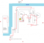
This is what I gathered by noticing the geographic directions V was looking at while sitting in the passenger's seat, looking at the left side of the vehicle. At first V kept staring into the West while driving, which means they were going up North. The rest follows. View attachment 11014439
The green circle is the area near V's apartment. The black line shows the path of Dex's car. The gray line roughly shows V's path after getting out of their vehicle, going to the ripperdoc, getting in to their own car and driving to the spot I consider CRUCIAL - the red spot.
We shall now move on to the 3rd part..
3. The compass. It was extremely helpful. It's late here and I should be sleeping now, so I'm going to make it quick.
The 2018 48-minute gameplay reveal. The timestamp is 24:56. View attachment 11014442
Notice how V is looking South. Notice the Orbital Air logo and other distinctive features that the Arasaka complex has. Also note the metro line visible in the center of the screenshot.
Now, let's triangulate. Let's see what they will see when they turn left, overlooking East. View attachment 11014445
The timestamp is 25:02.
Note how they're overlooking East. Notice the same bridge, as well. It's pretty important.
SO, WE HAVE THE MOST IMPORTANT COORDINATES now done. And this is also the part where any other previous assumptions fail. And this is where I failed at first too. Let's map the area out according to V's route which I've just displayed. View attachment 11014448
This is the only situation, in which these coordinates and everything we know about the immediate area (Arasaka, the Cluster, the Bridge) just fits in. Including V's route! We can map out the precise layout of the river bank west of the Cluster and north of Arasaka by following the boulevard V took.
This is where all the previous assumptions fail. The coordinates don't match up anywhere else on the map. There is only one place that matches what I drew here. Wait for it.
So, let's take a look at what I drew on the final version of my map.
View attachment 11014451
Everything you need is written out here. And everything makes perfect sense.
Now let's compare it to the metro map - like in a circular path, we return to where we started
Let's take a closer look at an area that resembles this very closely. And there's more proof to come! Seriously.
BUT, alas, I have reached the limit of 10 files. I will start the next post shortly.
Post automatically merged:
So let's take a closer look at the very, very similar area on the metro map.
View attachment 11014457
See the resemblance? I think it is pretty striking.
Now, you may think that the exact layout of the banks differs just a little bit. But take a moment to think about how metro maps are composed - they are a very simplified projection of the city map. The rivers are flattened and straightened out. So take it with a grain of salt - and have another look at my interpretation of the immediate area as it actually may be in the game.
Now, I have some last things to add. Some additional proof.
Take a look at the metro lines again. Take a look at the yellow line which we established earlier to resemble the path of that metro train we saw at the end of the 2018 E3 trailer.
Do you see any resemblance?
MISINFORMATION (OUTDATED/INCORRECT/INCONSISTENT DATA?) IN CYBERPUNK 2077 PROMO MATERIALS
Notice that it reads clearly here that V is riding the M2 metro line.
However, the M2 metro line doesn't come close to Watson. But it must, as I'll prove now.
Here is the M2 metro line:
Yet it's not it. They showed V riding a different metro line, and stated he's riding the M2 line which he ISN'T.
Proof:
It clearly says the next station will be located in "the Glen" which is located somewhere in the center of the Central Island (let's call it that).
But it clearly can't be! He can't be near the center of the Central Island. So where is he?
Take a look.
We can CLEARLY see:
The now-well-known Arasaka building
The now-well-known Bridge
And a tiny bit of the Cluster
This for sure must be Watson. What line is it then?
Well, triangulating this perspective with the location of both the Arasaka building and the Bridge, we determine it must take place somewhere over here:
Let's see what the metro map tells us. It will serve as proof. If a line goes through the location I pinpointed in green, and in the right angle considering the perspective overlooking the bridge and Arasaka and what not, it will be definite proof that everything in fact takes place where I showed you. The evidence is just too strong.
Let's take a look at the metro map.
And, well, THIS IS IT!!!
It all seems to lead us only to one conclusion!!!
This is it!!! The conclusion is that the location I pinpointed pretty much must almost exactly be the location of V's apartment on the map of Night City!
(By the way, so it seems now that the metro line must be M8, not M2. This is one of the inconsistencies I was talking about)
NOW, if this is truly it, then this megabuilding we saw right here:
Must be V's!!!
We can go even further. We can even determine the heckin' FLOOR V's APARTMENT is on!!!
It must be somewhere over here!!!
Don't you guys think it's crazy how I could go from a couple of screenshots, trailers and a metro map to.. locating the precise location of V's apartment, and the precise floor where they live?
ISNT THIS FREAKIN INSANE?
Sorry for patting myself on the back so much here. But I'm just too crazy now knowing that I probably figured out the map of the game I'm waiting for the most in my life!
Haha, thanks. Well, it would seem fitting but also... KIND OF gay that Sherlock is discovering the limits of Watson.. kek
Post automatically merged:
Off-topic fun fact:
This guy's name is Stephan Torquil. Googling "Cyberpunk 2077 Stephan Torquil" literally 0 results come up. It's so exciting finding something out before anybody does I'm sure when the game comes out there will be thousands of results after googling such a phrase.
Nah I think you're too far to the East on the map. I believe this is the rough path in the demo.
The part of the city Hughes Green is in appears to be near the boarder between Westbrook, City Center and Heywood whereas we are explicitly told the demo is in Watson. Watson is to the West of Hughes Green just North of City Center. Also, we are told by Stout that V will meet her on the way to the NID (North Industrial District). V then travels mostly North and a little east to get to the meeting place with Stout. Going North and a little East from Hughes Greens would not be in the direction of the Northern Industrial District.
So I think the map looks more like this overall:
Edit: Also keep in mind it is very UNLIKELY that the metro map is to scale or strictly accurate as far as N/S/E/W goes. Subway maps IRL take liberties with that sort of stuff in order to get all of the information on them in a coherent fashion.
This is what I gathered by noticing the geographic directions V was looking at while sitting in the passenger's seat, looking at the left side of the vehicle. At first V kept staring into the West while driving, which means they were going up North. The rest follows.
Dex's car makes a lot more turns than that. You actually see him pass Marsala studios right outside V's apartment twice. See: 12:52, (as V walks out) 14:58 & 16:02 (both in car). They're riding around in circles with some random turns added in. If you try you can follow it on the blue lines I drew above. They're clearly traveling on a few of the same roads more than once though.
Of course ... I could easily be wrong. But this is my best guess.
Sir_Parsifal, while I truly admire your deep analysis of this, I have to say I disagree with your pinpointing of V's location.
First - yes, Metro map serves as a scheme and isn't to scale usually, but if V really was where you said she was in the 2018 demo, this means that the map is unbelievably small. Why?
In the demo in 2018, they clearly said V starts out in Watson - they emphasize that her apartment and megabuilding is there. So if you look at the metro map, you can see that Watson is waaay further away than where you pinpointed it. And seeing how V doesn't drive out of Watson at all when going around with Dex (I drew a careful examination of her path a while ago), she is still in Watson when she leaves Dex' car. After that, she drives less than a mile to the spot where the famous Night city vista of the skyscraper cluster is.
So either the map is really small for V to travel from Watson to where you pinpointed her location in such a small time and distance, or you're unfortunately wrong.
Even if the Metro map were hugely distorted with it's metro lines and could in no way serve as a location marker, there's one other thing disproving your supposed location of V. It's simply that on that map, the districts are written. So no matter how distorted the map, you pinpointed V's location somewhere south of Westbrook, far away from Watson, past the City Centre and north of Heywood, almost in the proximity of San Domingo. I realize that precise metro lines could be off (and probably are), but no matter how mismatched the map is with them, the district names are somewhat of a good indicator where one is.
If you were right, V would have traveled across more than half the city map while going from Dex' leaving point (which is only two blocks away from her megabuilding - again, seen on the drawn map below) to seeing the Night city vista when the van shooting in 2018 demo happened. That's one short trip then. One that makes your guess at her location highly unlikely.
Still, I really appreciate your hard work
Edit: added my sketch. Notice that (for no reason - I was tired back then) I put North on the bottom.
It was not my idea originally, but I agree with the suggestion that the map makes more sense if we rotate the compass so that north is in the top right corner. This is my version of the map from about a year ago, with the landmarks and points of interests (marked as colored dots) placed according to what I could figure out from the quest markers and some triangulation:
In particular, this rotated approach places the Orbital Air Space Center correctly on the island on the left side of the map, and the skyscrapers visible from V's apartment and in the distance at the end of the 48 minutes demo are the city center. Edit: this would need to be updated with information from the new gameplay demo, though.
It was not my idea originally, but I agree with the suggestion that the map makes more sense if we rotate the compass so that north is in the top right corner. This is my version of the map from about a year ago, with the landmarks and points of interests (marked as colored dots) placed according to what I could figure out from the quest markers and some triangulation:
I think it's more the metro map stretches out on the edges in Watson an Pacifica. So parts look more diagonal on the map than true North South. It's likely done to accommodate getting all the metro lines and locations in the visual representation of the map. Again, I could be wrong ... but that's my guess.
It is possible, the metro map might not be very accurate either way. For anyone interested in experimenting with the scale and rotation, I have the same map as separate layers, only the metro map, and the grid and POIs. The latter should be more or less consistent within itself, based on the compass, quest marker distances shown, and triangulation, but obviously not 100% accurate, it is still only approximation based on screenshots. One exception is the location of the metro in the trailer (large red dot), that is entirely a guess.
It is possible, the metro map might not be very accurate either way. For anyone interested in experimenting with the scale and rotation, I have the same map as separate layers, only the metro map, and the grid and POIs. The latter should be more or less consistent within itself, based on the compass, quest marker distances shown, and triangulation, but obviously not 100% accurate, it is still only approximation based on screenshots. One exception is the location of the metro in the trailer (large red dot), that is entirely a guess.
Who knows if the metrosystem/metromap wasn't changed.
Half the station names on the one from last years trailer are placeholder names and repeat multiple times.
By the way, one more reason why I think the metro map might be rotated, and that I forgot to mention is that based on the gameplay demo alone, the canals, major roads, and metro lines are typically running in N-S or W-E directions, but on the metro map, almost everything is diagonal.
I've read your doubts, don't worry. See, we have to ask ourselves a question.
Why would the metro map be tilted?
It's usually tilted when there is some geographic peculiarity in the city that is more recognizable than the usual North-South axis projection. For example, the Manhattan Island. It would be weird to place it at an angle on a subway map - it's much more helpful if the map is adjusted to the angle of the Island. Thus the metro map of New York is tilted compared to the North-South axis.
Now, why would it be tilted here? It seems like pure wishful thinking.
Though I have to add that the situation with the highway "heading to NID" as in the Northside Industrial District does seem to add a little doubt to my location, but then there are other things that add a ton of doubt to your location as well. For example, the metro lines match up perfectly in my location, while they either don't match up or are non-existent at all at your location. And my location requires fewer assumptions - it doesn't require tilting the map. It assumes the most common geographic orientation.
I would say there is a 60% chance that my location is right, and 40% chance that your location is right. But all in all, it seems to be very weird - some things suggest my location is right, and some things suggest it's wrong. And the weird thing is, for your location the same thing happens - some things suggest your location is right and some that it's wrong. It's a conundrum, sure, but I think together we can work this out. Remember, we aren't competing We are working together.
Now, regarding the NID. I think it's not a definite refutation of my proposition. She said something like "take the first exit off Skyline heading towards the NID." This could mean two things - either you take the first exit off Skyline WHILE heading towards the NID, OR you take the first exit off Skyline WHICH (either the exit or the Skyline - I'll explain in a moment) IS heading towards the NID. She then specifies that it's "the storm channel under the overpass."
The term "Skyline" could also mean two things. It could mean the famous skyscraper cluster, but what about a different idea? It could also mean something else. Either a highway, or some fixed airway for flying cars - it's entirely a possibilty.
It's also possible that the highway or airway or whatever is heading towards the NID, but not necessarily in a straight line, it's just that the final destination of that highway is located somewhere in the NID.
The other thing that puts doubt in the more northern, more western location is this:
Look at the skyscrapers visible here, closely. According to you, this should be the City Center. Not even mentioning the fact that it looks quite small, smaller even than the most distinct skyscraper cluster, there is another thing wrong with considering this to be the City Center.
Look at the fragment of the map shown in the Collector's Edition. It depicts the upper part of the City Center, part of the river and part of Little China.
Look closely and try to compare the skyscrapers (visible slightly off-center to the right) from the gameplay screenshot to supposedly the same ones. They look different. Little China seems different too. The architecture of pseudo-LC (to the right of V's megabuilding) seems to be very low-height. Meanwhile if you zoom in on Little China on the Collector's Edition map, you can see the buildings there are of considerable height. There is also no lone skyscraper in the distance to be seen.
Honestly, the only inconsistence I can see with my location so far is the highway heading to NID, but again, this could be explained somehow by various things. Meanwhile there's a ton of other evidence in favor of my location, and in regards to your location, with the exception of the NID inconsistency, I don't think there's any other "evidence."
I have to admit I did consider this location to be the one at first because of the river layout, but I scrapped it after noticing the geographical directions don't match. Then you guys told me the metro map is tilted, but.. why would it be? Again, we return to the beginning of my post.
I recommend everyone reading my analysis thoroughly again. The proof is there and it's pretty strong, it seems to me you guys just paid attention to the map and completely ignored everything else that I pointed out along the way.
It was not my idea originally, but I agree with the suggestion that the map makes more sense if we rotate the compass so that north is in the top right corner. This is my version of the map from about a year ago, with the landmarks and points of interests (marked as colored dots) placed according to what I could figure out from the quest markers and some triangulation:
In particular, this rotated approach places the Orbital Air Space Center correctly on the island on the left side of the map, and the skyscrapers visible from V's apartment and in the distance at the end of the 48 minutes demo are the city center. Edit: this would need to be updated with information from the new gameplay demo, though.
Nope, that's definitely not it. North can't be in the top-right corner, it can only be in the top-left corner as far as I see it. So we come back to arguing with Rawls's vision, sorry.
Nah I think you're too far to the East on the map. I believe this is the rough path in the demo. View attachment 11014535
The part of the city Hughes Green is in appears to be near the boarder between Westbrook, City Center and Heywood whereas we are explicitly told the demo is in Watson. Watson is to the West of Hughes Green just North of City Center. Also, we are told by Stout that V will meet her on the way to the NID (North Industrial District). V then travels mostly North and a little east to get to the meeting place with Stout. Going North and a little East from Hughes Greens would not be in the direction of the Northern Industrial District.
So I think the map looks more like this overall:
View attachment 11014544
Edit: Also keep in mind it is very UNLIKELY that the metro map is to scale or strictly accurate as far as N/S/E/W goes. Subway maps IRL take liberties with that sort of stuff in order to get all of the information on them in a coherent fashion.
Dex's car makes a lot more turns than that. You actually see him pass Marsala studios right outside V's apartment twice. See: 12:52, (as V walks out) 14:58 & 16:02 (both in car). They're riding around in circles with some random turns added in. If you try you can follow it on the blue lines I drew above. They're clearly traveling on a few of the same roads more than once though.
Of course ... I could easily be wrong. But this is my best guess.
Regarding the tilt of the metro map, I addressed that in my previous post. Let's move on to some other points you made...
So basically, I feel like with the district boundaries you're focusing too much on Watson, and then for the rest of the districts you're just letting them be big blobs without much care. I tried to think realistically about it. So the districts can't be too big - it would be weird. It would also be weird for a single district to occupy two banks at the same time (maybe I'm in the wrong here though). I tried making the district sizes kind of proportional and realistic.
You have to notice that the district names' locations aren't rigid designations of where precisely the districts are. There's a lot of empty space in the middle of the map without any district names, with the district names mostly being placed on the outer rims of the city. Why?
Because metro stations, that's why. They had no other place to fit the district names but on the outer rims of the map. Thus the location of the name "Watson" doesn't tell us very much.
We know that Kabuki is very much so in Watson. Kabuki probably doesn't end where the names of the stations pop up, it probably goes even a little bit further East. This makes Watson definitely a bit wider than you think it is. That's why I decided its boundaries go like this
The location of the All Food Plant is completely wrong though. Ignore it for a little while, I'll fix it in a minute.
tldr - You shouldn't be so harsh on situating the boundaries of the district right around where the district name was placed. My apartment most probably still is in Watson, and well - there's a ton of other proof for it being where I said.
By the way, one more reason why I think the metro map might be rotated, and that I forgot to mention is that based on the gameplay demo alone, the canals, major roads, and metro lines are typically running in N-S or W-E directions, but on the metro map, almost everything is diagonal.
>the canals
Nope. They run diagonally only when the map is tilted. When it isn't (my proposition) they run nicely along the N-S and W-E axes. So I guess it only further proves my point.
>major roads
Which ones? How could you tell the layout of the major roads of the whole map based on a metro map?
>metro lines
Which ones? Didn't notice that.
Nope, that's definitely not it. North can't be in the top-right corner, it can only be in the top-left corner as far as I see it. So we come back to arguing with Rawls's vision, sorry.
I may have missed something, but why is north = top right corner definitely wrong? It is the only orientation that puts Orbital Air at the place where it should be on the map, it makes the skyscrapers seen from V's apartment the city center, rather than Kabuki (which is an industrial area), and has certain train lines and canals where expected from the gameplay demo. Notably, there is a train line running to the east at the point of the panning view (crossing over the canal), and another one at the meeting point in the same direction. And when the car turns to the right (east) before the meeting point, the canal on the right side apparently takes a turn to the east as well, and the area with the skyscrapers looks like it is on a large island.
Making north = top left contradicts the above:
White = V's apartment
Pink = skyscraper on the other side of the canal, visible from V's apartment
Small red = ripperdoc
Light blue with white outline = left turn with the car before the scavenger attack
Green = point of panning view
Orange = tower that can be seen about to the south from this point
Lime = large building with Arasaka logo
Large cyan = Orbital Air
Dark blue = building with antennas on the roof (seen shortly before the meeting point)
Sky blue = large "cyberware" building seen on the right before the meeting point
Magenta = meeting point
Small cyan = All Food factory
Purple with white outline = "Fuyutsuki" building visible at the end of the demo
Large red = metro location on the trailer, this particular one is only a guess and probably wrong